Wayne County under flash flood watch, wind advisory as tropical system approaches
By Steve Herring
Published in News on August 28, 2017 1:42 PM
 Full Size
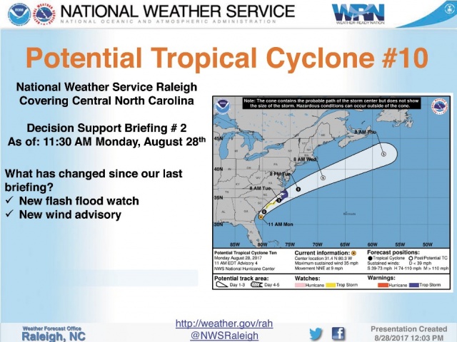 Full Size
Wayne County and central North Carolina are under a flash flood watch and wind advisory from 8 tonight until 8 p.m. Tuesday.
Meanwhile tropical storm watches and warnings have been issued for the North Carolina coast.
A tropical storm warning means tropical storm wind conditions are expected somewhere within this area and within the next 36 hours.
Rain bands will move into the area this evening, with some of those bands containing heavy rain from late tonight through about mid-day Tuesday, according to the National Weather Service in Raleigh.
Between 2 and 5 inches of rain is expected along and east of Interstate 95 as potential tropical cyclone 10 tracks northeast along or just inland of the Carolina coast tonight and Tuesday.
The storm poises the risk for localized flash flooding of urban and poorly drained areas.
Motorists are reminded to never drive across water-covered roadways since most flash flood deaths occur in automobiles.
Winds may gust up to 40 mph as the bands move across the area, according to the National Weather Service.
The winds will likely cause isolated pockets of downed trees and power lines -- most likely from later tonight through about mid-day Tuesday, and for areas along the I-95 corridor and eastward.
According to the National Weather Service, minor flooding of the Neuse, Cape Fear and Tar rivers and their tributaries can't be ruled out during the middle of the week, but mainly if the area receives more rain than what's currently expected.
As of 1 p.m., the Neuse River was at about 3.5 feet and is expected to reach 5.2 feet by late Wednesday -- still well blow its flood stage of 18 feet.
The area will enjoy a break in the rainy weather Wednesday and in to Thursday afternoon.
But a slow-moving cold front, combined with some remnant Harvey moisture, will result in additional, mainly light rain for the central part of the Thursday through Saturday.
While it won't be raining that entire time, an additional one to two inches of rain could fall.
The rain will bring cooler temperatures today with a high of 74 degrees forecast falling to 64 overnight.