Driving conditions deteriorating
By News-Argus Staff
Published in News on March 12, 2018 5:07 PM
 Full Size
National Weather Service
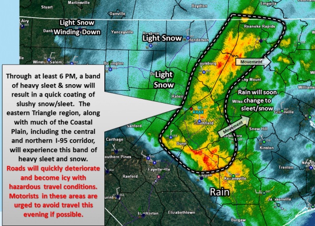
A brief burst of sleet and snow moves across the area through at least 6 p.m.
UPDATE ---- Wayne County Public Schools will operate on a 2-hour delay Tuesday due to the threat of overnight freezing and the potential for slick roads.
Hazardous road conditions are possible in southwest Wayne County as a brief burst of sleet and snow moves across the area through at least 6 p.m.
The band of precipitation is moving to the northeast.
The burst of snow/sleet could result in a quick coating of slushy accumulation in eastern Wake County, all of Johnston County, northern Sampson County and southwest Wayne County.
Much of the coastal plain, including the central and northern Interstate-95 corridor, will experience this band of heavy sleet and snow.
Wayne Community College is closed because of the weather threat. Wayne County Public Schools canceled after-school activities.
Wayne County is under a winter weather advisory until 10 p.m. today with possible snow accumulation of less than half an inch possible.
Precipitation will begin as rain, then rain and snow before becoming all snow after 8 p.m. and then gradually ending.
Today's high temperature will be near 42 degrees falling to around 31 overnight.
Tuesday will be sunny with a high near 51.
The advisory, which had been in effect for counties to the north and west of Wayne County, was expanded south and east this morning to include the Triangle, Roanoke Rapids, Sanford and Goldsboro.
During the day, rain will change over to a mixture of snow and sleet, with precipitation type changing over to a wet snow during high precipitation rates, according to the National Weather Service.
Total snow/sleet accumulations of up to two inches will be possible, with localized higher amounts to the north and west of Wayne County.
However, preceding warm and wet ground conditions, along with the relatively high March afternoon sun angle, will mitigate accumulation, especially on pavement, according to the weather service.
A vigorous upper level trough will move southeast through the Carolinas today and off the North Carolina coast this evening.
While there remain some uncertainties, rain is expected to transition to a mixture of rain, sleet, and heavy wet snow from the late morning, through the afternoon evening.
Surface temperatures hovering near to just above freezing will likely limit significant accumulations.
However, a period of slush will likely accumulate once precipitation rates increase. A few slick spots will be possible, especially in areas along and north of Interstate 40 by the late afternoon and evening hours.
The latest road conditions for North Carolina can be found online at DriveNC.gov.