Tropical storm force winds may arrive early Monday morning
By Steve Herring
Published in News on September 7, 2017 8:10 PM
 Full Size
As of 5 p.m. Thursday it appeared increasingly likely that the state will experience impacts, possibly "significant" impacts by Hurricane Irma, according to the National Weather Service.
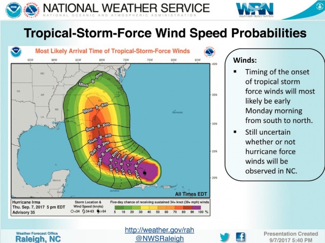
It is still uncertain as to whether or not hurricane-force winds will be observed in the state.
The onset of tropical storm force winds will most likely be early Monday morning from south to north.
Most of the state should expect "significant" rainfall that potentially could cause inland flash flooding and dangerous travel conditions.
Rain is expected to arrive late Sunday night/Monday morning, ending early Tuesday.
The storm track is becoming clear, but not yet set with landfall possible over Georgia/Carolinas, according to the National Weather Service.
The latest center track places the storm over the Miami area around 2 p.m. Sunday moving to near Savannah, Georgia, by 2 p.m. Monday and in eastern Tennessee as a tropical storm by 2 p.m. Tuesday.
However, the storm could track anywhere inside the forecast cone.
River flooding is expected because of Hurricane Irma, but officials with the National Weather Service Raleigh office do not expect the level of flooding experienced in October 2016, from Hurricane Matthew.
As of 5 p.m. Thursday the Neuse River was at 6 feet. It was predicted to reach 6.3 feet by late Friday before falling to below 5 feet early Tuesday.
The flood level is 18 feet.
As of 5 p.m. Thursday Hurricane Irma packed winds of 175 mph, down slightly from 185 mph. It was located 65 miles southeast of Grand Turk Island moving west northwest at 16 mph.
Hurricane Jose will affected some Caribbean Islands already hit by Hurricane Irma, but at this time it is not expected to affect the U.S.
Read the News-Argus or follow the paper online at www.newargus.com or follow the paper on social media for the latest updates and storm-related information.