Pipeline access, no new facility at H.F. Lee Plant
By Steve Herring
Published in News on April 10, 2017 8:11 AM
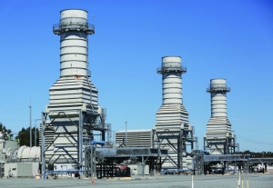
The Duke Energy H.F. Lee Plant is in its biannual outage phase when portions of the plant are closed down for maintenance. The simple cycle side of the plant seen here remains open as the combined cycle side equipment is being checked and replaced in preparation for the coming colder months.
Duke Energy has no plans to build any permanent facilities in the area of the H.F. Lee Plant active ash basin that the company is seeking to have removed from the floodway map of the Neuse River's 100-year flood plain, company officials say.
However, Duke Energy is planning to locate a portable water treatment plant within the active ash basin that will treat water as the company works to close the basin, said Erin Culbert, a company spokesman.
The water treatment plant would be removed at the end of the closure project.
A floodway is the Federal Emergency Management Agency-designated part of the flood plain where development is generally prohibited.
Meanwhile, Duke would benefit once the Atlantic Coast Pipeline is operational.
The H.F. Lee Plant was switched from coal to natural gas approximately four years ago.
The plant is fed through a Piedmont Natural Gas line, which is owned by Duke Energy.
The gas supply for the Lee facility now originates from the state's only interstate transmission source, the Transco line located west of Charlotte, and flows through Piedmont Natural Gas's vast network of transmission and distribution lines to the plant, Ms. Culbert said.
"Once the Atlantic Coast Pipeline is in operation, gas from the ACP line will flow into Piedmont's existing distribution framework to be delivered to our gas plants," she said. "Access to the ACP, a second interstate pipeline in North Carolina, will allow us to purchase gas from either line that has the greatest availability and is offering the best price for our customers.
"It also gives us a second source of gas -- from a different location -- providing greater resiliency and reliability to the system."
Marl Schillinger of Geosyntec Consultants last Tuesday told Wayne County commissioners that his company had been hired by Duke to in order to correct 40-year old historical errors in FEMA maps that incorrectly placed the coal ash basin in the floodway.
The process, referred to as a Letter of Map Revision, has gone through state, city and county review.
Data from more accurate topographical maps show that the active basin is about 15 feet higher than the surrounding grade with a surrounding dike wall eight to nine feet higher than the 100-year water surface elevation, Schillinger said.
In June 2015, the company announced that the four ash basins at the Lee facility should be excavated because the low-lying basins are not a suitable location for the material long-term.
"In planning for safely closing ash basins, we've been conducting a variety of engineering studies," Ms. Culbert said. "As part of that process, we learned that the FEMA flood map for the H.F. Lee Plant property was outdated and did not accurately reflect the active ash basin and that its elevation is out of the flood plain.
"This prompted us to initiate the request to revise the map in January 2016. We've been working through the process since January 2016. This has involved discussions and input from the county, city and N.C. Department of Public Safety. Ultimately, it will result in a more accurate FEMA flood plain map that we and neighbors can use to inform decisions about their properties."
In December 2016, the company announced plans to build an ash reprocessing unit at the plant site that will make the ash better quality for concrete products.
The ash-processing plant will not be located inside the active ash basin because the ash has too much carbon to be used successfully in concrete, Ms. Culbert said.
The project is a "great way" to recycle the material and prevent permanently disposing of such a valuable construction product in a landfill, she said.
Duke's property isn't the only area that will be affected by the revised maps.
If the map revisions are approved, four residential structures will be added to the flood plain while another eight would be removed. Altogether, 16 structures will be added and 12 others removed.
During his comments at the board meeting, Schillinger said that property owners affected by the changes should contact their insurance carriers.
Property owners affected by the modified map will be notified by letter later this month, following final state approval, and will have 90 days from that time to direct comments or question to the Wayne County Planning Department.
The maps would become effective following the 90-day period.
Other Letters of Map Revision are possible, Ms. Culbert said.
"As ash basin closure planning continues, it's likely we'll identify other updates that are needed to FEMA maps," she said. "We also may need to update some FEMA maps after basins are closed to reflect any flood plain changes.
"For example, after we excavate the basins at H.F. Lee, that will decrease the flood plain for neighbors, and we'll want to reflect those adjustments."