Wet ... getting wetter
By From staff reports
Published in News on September 30, 2010 1:46 PM
 Full Size
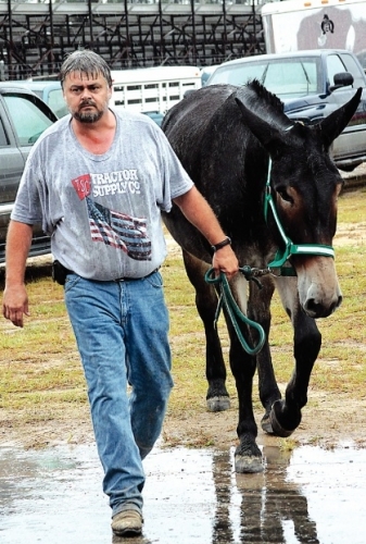
News-Argus/BOBBY WILLIAMS
A soaked Terry Lee of Mount Olive leads one of his mules through the rain Wednesday afternoon to enter it in the Wayne Regional Agricultural Fair. Rain canceled the fair's midway today but officials expect the skies to clear by Friday and the gates to open at 4 p.m. as scheduled. The meat goat show scheduled for tonight will go on as planned.
Ponding on several city and county roads has not been severe enough to warrant closing them. However, the potential for standing water on the roads did prompt Wayne County Public Schools to delay today's opening by two hours.
"As of now (10 a.m.) there are no roads closed in the county or city," said Mel Powers, Wayne County emergency management and security coordinator. "There has been some ponding, but nothing to close the roads over.
"(Conditions) are kind of surprising. I like it a lot."
The county and surrounding areas remain under a flash flood watch until 6 p.m., meaning that conditions are right for such flooding to occur. A flash flood warning was set to expire at noon.
Drivers are cautioned to never drive their vehicle in water-covered areas. As little as 6 inches of water can cause a person to lose control of his vehicle. Two feet of rushing water can carry away most vehicles -- including SUVs and pickup trucks.
A tornado watch was in effect until 1 p.m. for the area.
Some ponding was reported on Lancaster Road and Big Daddy's Road near Pikeville and on Ninth Street and Wayne Memorial Drive, he said. However, the water did not cover the streets.
Powers said schools were delayed because of a concern that ponding water on roads would be difficult to see at 5 or 6 a.m. when buses would normally start making their rounds.
City Manager Joe Huffman said that as of 9 a.m., the city looked as if it had avoided significant complications resulting from the storm.
"The creek is up at Stoney Creek, but the streets are all looking good," he said. "So far, everything's fine."
Also, Powers said there have been no reports of any trees down.
Just a few days ago, the county and state were in the early stages of drought.
A low pressure system moving upward from the south has dumped as much as 9 inches of rain in some places, especially along the coast.
The National Weather Service said this morning that 4-5 inches of rain fell on Wayne late Wednesday and early today, adding to the 5-6 inches that fell earlier this week. Another 1 to 2 inches were expected today.
The chance of precipitation is 100 percent today, but the rains were expected to taper off this afternoon as the system shifts eastward taking the moisture to the coast.
In Duplin, roads were flooded mostly in the southern part of the county. Emergency personnel were called to one home in Chinquapin that had reportedly been flooded out.
Showers are likely tonight with rainfall amounts between a quarter and half of an inch possible. The low will be around 66. The wind will be calm, becoming north between 7 and 10 mph.
Friday is forecast to be mostly sunny with a high near 74 and a north wind between 10 and 16 mph. Friday night should be clear with a low around 54 and a north wind around 7 mph.
It should be sunny on Saturday with a high near 73 and north wind around 8 mph. Saturday night is expected to be mostly clear, with a low around 51.
The forecast is similar Sunday before a chance of showers returns on Monday. Partly sunny skies are expected with a high near 68 and a 30 percent chance of precipitation. The possibility of showers continues into Monday night. The forecast is for mostly cloudy skies with a low around 52.