Forecast: Ice
By Steve Herring
Published in News on January 29, 2010 1:46 PM
 Full Size
News-Argus/BOBBY WILLIAMS
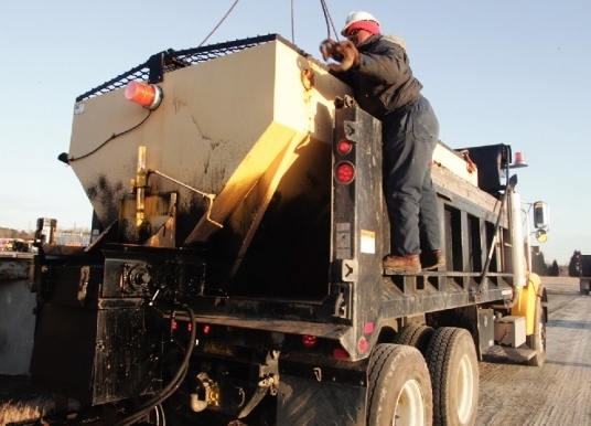
Wayne County Department of Transportation employee James Dean unhooks a cable after placing a salt and sand spreader in the back of a dump truck this morning. DOT workers have spent the past several days putting down brine on the county highways, getting ready for this weekend's winter storm.
 Full Size
News-Argus/BOBBY WILLIAMS
Eva Suggs of Goldsboro eyes the bread shelves at Carlie C's grocery store on Wayne Memorial Drive this morning. All across Wayne County, people were stocking up on essential items in preparation for what forecasters say will likely be a nasty weekend, weather-wise.
A Winter Storm Warning has been issued for eastern North Carolina in advance of a storm that could coat Wayne County with up to a quarter of an inch of ice and a potential accumulation of 2 to 4 inches of a wintry mix.
The icy mix, accompanied by 15-20 mph winds, poses a potential for downed trees and power lines.
Local Department of Transportation work crews Thursday began spraying the county's main roads with a salt brine solution in an attempt to keep them clear when the bad weather hits, and Progress Energy officials are asking customers to take steps to prepare themselves as their crews ready for power outages.
Because of the forecast, the county has announced that Wayne Memorial Library and its branches will be closed Saturday and Sunday, while the landfill and convenience sites will be closed Saturday. Additionally, county officials said GATEWAY buses and vans will not run Saturday. Wayne Community College also will be closed Saturday.
All Wayne County Public Schools sporting events schedule for today have been canceled.
The warning is for 6 p.m. today through mid-day on Saturday.
"The precipitation could start after sunset with the heavy amounts falling after midnight," said Barrett Smith, a meteorologist with the Raleigh office of National Weather Service. "Wayne County is in the transition area where there will be periods of snow mixed with sleet and freezing rain."
The storm could end as snow Saturday afternoon.
Sleet and freezing rain make it difficult to forecast snow accumulation, he said. However, there is the potential for 2 to 4 inches, depending on the amount of sleet and freezing rain.
"One of the hardest things to forecast is where the transition line will be," Smith said.
Freezing rain is a rain that freezes once it strikes a surface like trees and power lines. The chilly wind factors into the potential for fallen limbs and power lines.
Today's temperatures should reach the low 40s. Saturday's temperatures will range from the upper 20s to low 30s.
"If there is snow on the ground, it will make it colder at night," Smith said.
Nighttime lows Sunday into Monday morning will be in the 20s to teens, with the coldest blast of air arriving Monday morning.
It will struggle Sunday to get above freezing, especially if there is snow on the ground, Smith said.
Temperatures will remain in the 30s on Monday moderating to the mid- to upper 40s and possibly a seasonable 50 by Thursday.
Meanwhile, forecasters are looking ahead to another potential weather system by the end of next week.
"We are not looking for it to be a winter system, just rain," Smith said.
"I hope it is snow (tonight)," said Luther Thompson, DOT maintenance supervisor. "Ice, there is not much that we can do about. We will try to keep spraying the salt brine solution to hopefully break down the ice. If the road looks wet, assume that it is icy. Be patient and take your time.
"We are looking at a long weekend for us."
Crews will be on duty Saturday and a meeting was scheduled for Friday morning to determine the best time to bring crews in.
The county has 22-24 pieces of equipment staged across the county that will be ready to respond, Thompson said. This afternoon workers will be attaching plows and other equipment to the trucks.
Thompson said DOT would concentrate on keeping the four-lane and primary roads clear before branching off on secondary roads.
It's also likely to be a long weekend for crews from Progress Energy Carolinas, which a spokesman said is preparing for a significant ice and snow event.
David McNeill, spokesman for Progress Energy, said their crews are working to make sure all their trucks and equipment are ready to go. Additionally, he said, extra crews from Progress Energy Florida have already been brought in and are standing by to lend a hand.
"The whole company is certainly engaged and monitoring the storm," McNeill said. "We certainly are expecting significant ice and snow, and ice can cause power outages from the extra weight on lines or from tree limbs that may fall on lines."
In the meantime, he said, "we are absolutely encouraging our customers to be prepared."
That means, he continued, stocking up on non-perishables like canned goods and bottled water, batteries for flashlights and making sure any indoor heaters are properly ventilated.
Customers can report outages at Progress Energy's 24-hour hotline at 800-419-6356.
"That way our crews can respond quickly," McNeill said.