Storm hits area, leaving some damage
By Steve Herring
Published in News on August 11, 2008 1:41 PM
The roof of a local church was damaged, power lines were downed and limbs and other strewn debris were left in the wake of a thunderstorm that rolled across Wayne County Sunday night.
No injuries were reported.
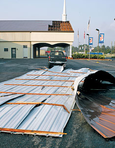
News-Argus/Bobby Williams
A large part of roof from the Pathway Christian Academy at 1302 South George Street lays in the parking lot. Last night storms and high winds ripped off a section of the roof. Last night storms did minor damages throughout Wayne County.
The storm struck the northern part of the county around 8:30 p.m. and moved south, weather spotters said. Three-quarters of an inch of rain fell in Goldsboro and about an inch and a quarter of rain fell in Mount Olive, where no problems were reported.
The Goldsboro Fire Department was called to Pathway Ministries on South George Street after a small portion of roof near an entrance canopy was ripped off.
No one was inside at the time, said Goldsboro Assistant Fire Chief Gary Whaley.
Whaley said there did not appear to be any major damage to the building's interior. A city building inspector was called to the scene as well, he said.
The power lines downed by the storm are located just south of the church near the Fat Cat Pawn Shop, said Delbert Edwards, Wayne County emergency services communications supervisor.
Edwards said he did not know of any areas in the county without power this morning.
He said he was not aware of any damages to homes or other property caused by fallen limbs and trees. There were no reports of trees blocking roads.
National Weather Service Forecaster Jason Beaman said storms like the one that came through Wayne County on Sunday are rare.
The National Weather Service in Raleigh received reports of power lines down in the southern part of the city around U.S. 117 and South George Street.
"We had numerous reports of trees down throughout the city, and southwest towards Grantham, there were reports of nickel-sized hail," Beaman said.
Summer storms are normal this time of year because of the combination of heat and humidity, which puts the ingredients in place for unstable air. But Beaman said the unusual part was the fact that the jet stream, which is made up of strong upper level winds, dipped farther south than normal. This factor brought in much stronger winds than usually accompany such storms in eastern North Carolina.
"These stronger winds are typically much farther north. They dove south out of Canada and will be moving farther east and north today," Beaman said.
Somewhat drier air is expected in the storm's aftermath, and tonight's lows should dip into the 60s, he said.
But there remains a chance of showers and thunderstorms in the county over the next few days.