Hurricane season could be more active than normal
By Steve Herring
Published in News on June 3, 2018 3:05 AM
 Full Size
News-Argus file photo
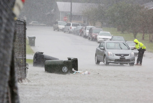
Hurricane Matthew pounded Wayne County on Oct. 8, 2016, and resulted in hazardous driving conditions in the city and county.
 Full Size
News-Argus file photo
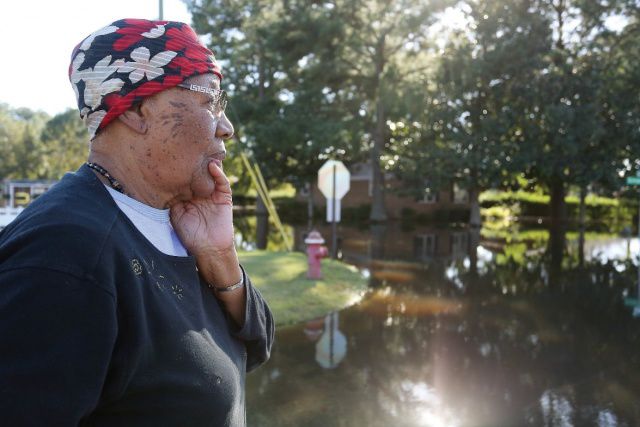
Lois Waters stares across the floodwaters at the corner of Bunche Drive and Simpson Street, in Goldsboro, several days after Hurricane Matthew pounded Wayne County, in 2016. Waters was evacuated by boat and unable to return home until the floodwaters receded.
Even as survivors of 2016's Hurricane Matthew continue to struggle to rebuild, the country is bracing for what is predicted to be a near- or above-normal season that began Friday.
But perhaps the main thing that people should be getting out of the outlook is to check their preparedness plan and make sure they are ready if a hurricane or tropical storm threatens, said Dr. Jerry Bell.
Bell is the the lead seasonal hurricane forecaster for the National Oceanic and Atmospheric Administration at its Climate Prediction Center in Camp Springs, Maryland.
The center is forecasting a 75 percent chance that the 2018 Atlantic hurricane season will be near- or above-normal, Bell said. Forecasters predict a 35 percent chance of an above-normal season; a 40 percent chance of a near-normal season; and a 25 percent chance of a below-normal season.
There is a 75 percent chance of 10 to 16 named storms with wind speeds of 39 mph or higher. Forecasters predict five to nine could become hurricanes, which could pack wind speeds of 74 mph and higher. The prediction includes the possibility of one to four major hurricanes -- at a category 3, 4 or 5 with winds of 111 mph or higher.
"The hurricane season starts (June 1), but it runs through Nov. 30, so now is the time to start getting prepared for the hurricane season," Bell said. "In general, we often think of hurricanes as maybe just impacting right along the coast.
"But that is just simply not true. We just saw that with this tropical storm that went right up the Midwest. It brought tremendous rainfall along its path. Inland flooding is now the major cause of death from hurricanes and tropical storms."
More than 80 million people between the Atlantic Ocean and Gulf Coast are in an area that could be impacted by a hurricane, Bell said.
Coastlines have built up tremendously over the past few decades, greatly increasing the number of people who could potentially be impacted by a hurricane, he said.
"So that makes hurricane preparedness even more important than ever," Bell said. "We are seeing more storms, and we have so many more people who need to prepare."
NOAA will update the 2018 Atlantic seasonal outlook in early August, just prior to the peak of the season.
Alberto, the first named storm of the year, hit the U.S. Gulf Coast just days before the official start of the hurricane season.
"The peak months of the hurricane season are August, September and October," Bell said. "That is when about when 90 percent of the hurricanes form.
"Normally in June, July, we see one or two named storms. Typically in November, you might see one or two named storms, possibly a hurricane. That just depends on the specific conditions."
The possibility of a developing weak El Nino -- the periodic warming of the water in the eastern Pacific Ocean -- along with near-average sea surface temperatures across the tropical Atlantic Ocean and Caribbean Sea are two of the factors driving this outlook.
These factors are set upon a backdrop of atmospheric and oceanic conditions that are conducive to hurricane development and have been producing stronger Atlantic hurricane seasons since 1995, Bell said.
"We issue predictive ranges with a 70 percent likelihood of occurring," Bell said. "So it means our predictive range of named storms is 10 to 16.
"We would expect that in seven of 10 seasons, the predictive range would be correct, and they are," Bell said. "So the ranges that we give are consistent with the probabilities that we are giving it so they are pretty accurate."
An average hurricane season produces 12 named storms, of which six become hurricanes, including three major hurricanes.
It is not a prediction of hurricane landfall, Bell said.
"That is not a seasonal prediction because where hurricanes may strike, how strong they will be when they strike and how much damage and so on," he said. "That all depends on the weather patterns in place at the time the storm is approaching.
"And those weather patterns are simply not predictable this far in advance."
The National Hurricane Prediction Center does the predictions for the individual storms, he said.
Generally there is an idea about five days out as to where the storm might track, but it can vary quite a bit by storm, Bell said.
"A lot of storms, there is a fairly good steering current, which can give us a good idea of where the storm will track," Bell said.
At other times, if a storm forms in the Caribbean Sea and there is no real surrounding wind patterns to steer it, then it is more a matter of wait and see, he said.
As such the forecast lead time decreases, Bell said.
Human expertise, more research and technology -- especially continued development of computer prediction models -- have contributed to vastly improved forecasts, he said.
"It is just amazing how these computer prediction models have developed, just even over the last decade," Bell said. "One of the amazing things about this is the global data that we have now.
"I can look at global weather maps daily."
NOAA's suite of sophisticated technologies -- from next-generation models and satellite data to new and improved forecast and graphical products -- enable decision makers and the general public to take action before, during, and after hurricanes.
The National Hurricane Center has the hurricane hunter aircraft and new high resolution satellites including one that can be parked above the storm so it can literally watch the hurricane evolve, he said.
NOAA's fleet of earth-observing satellites is more robust than ever, with the successful launch of the GOES-17 satellite in March.
This satellite, along with the GOES-16 satellite -- now GOES-East -- contribute to a comprehensive picture of weather throughout the Western Hemisphere, allowing forecasters to observe storms as they develop.
The new polar-orbiting satellite, NOAA-20, will join the NOAA/NASA Suomi NPP satellite and use a suite of sophisticated instruments to gather high-resolution data from around the globe to feed NOAA's weather models, driving the three to seven day weather forecast that is critical to preparedness and effective evacuations.
The National Weather Service will run a version of the Global Forecast System (called FV3 GFS) with a new dynamic core alongside the current GFS model -- often referred to as the American model -- during the 2018 season.
This will mark the first dynamic core upgrade to NOAA's flagship weather model in more than 35 years, representing the first step in re-engineering NOAA's models to provide the best possible science-based predictions for the nation.
NOAA's hurricane-specific model -- the Hurricane Weather Research and Forecast system -- will be upgraded to offer greater resolution than ever before, increasing model resolution from 1.2 miles to 0.9 miles (2 km to 1.5 km) near the center of a storm.
Additionally, the Hurricanes in a Multi-scale Ocean coupled Non-hydrostatic model was first implemented in 2017 and will undergo upgrades for the 2018 season to include greater resolution, new physics and coupling with ocean models.
NOAA's National Hurricane Center will make the Arrival Time of Tropical-Storm-Force Winds graphics operational for this hurricane season.
One graphic displays the "earliest reasonable" arrival time of tropical-storm-force winds, at which point further preparedness activities could be hindered.
A second graphic displays the "most-likely" arrival time of tropical-storm-force winds.