Snow likely to fall after 5 p.m. today, 4 inches is expected by Thursday morning
By Steve Herring
Published in News on January 3, 2018 9:07 AM
 Full Size
National Weather Service
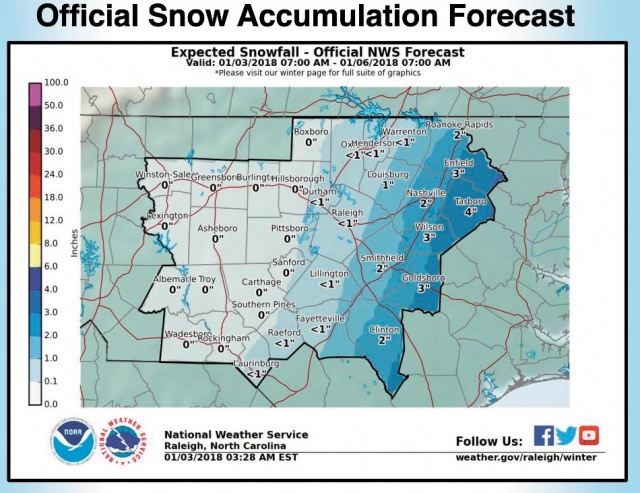
Snow is likely, mainly after 5 p.m. today, with the heaviest snowfall occurring overnight burying the eastern half of Wayne County under up to 4 inches of snow by Thursday morning.
Snow is likely, mainly after 5 p.m. today, with the heaviest snowfall occurring overnight burying the eastern half of Wayne County under up to 4 inches of snow by Thursday morning.
The western half of the county could be covered by up to three inches.
A winter storm warning is in effect from noon until 7 a.m. Thursday for much of the coastal plain of central North Carolina. The area had been under a winter weather advisory which has now been expanded west into the Triangle and Fayetteville areas from noon until 7 a.m. Thursday.
Snow is expected over the eastern part of the state, mainly east of U.S. 1, this afternoon through tonight.
Amounts will likely be highest along and east of I-95, according to the National Weather Service.
A band of heavy snow may occur, most likely east of a line from Roanoke Rapids to Goldsboro, but details about the exact location of such a snow band remain uncertain, according to the National Weather Service.
Hazardous road conditions are possible, particularly on bridges and overpasses, late today into Thursday. If you must travel, keep an extra flashlight, food and water in your vehicle in case of an emergency. The latest road conditions for the state you are calling from can be obtained by calling 5 1 1.
In Wayne County, snow is likely, mainly after 5 p.m. today with total daytime snow accumulation of less than a 1/2 inch possible. The high temperature will be near 35 with wind chill values as low as 6. The chance of precipitation is 60 percent.
Overnight there is an 80 percent chance of snow, mainly before 2 a.m. The temperature will drop to around 21 with wind chill values as low as 11. New snow accumulation of 2 to 4 inches possible.
There also is a 30 percent chance of snow before 8 a.m. Thursday and then sunny with a high near 33. New snow accumulation of less than a 1/2 inch is possible. The wind chill values will be as low as 10.
Frigid temperatures and low wind chills will persist through the rest of the week, with the worst of the cold occurring Thursday night through Saturday. In some areas, temperatures may not top the freezing mark Thursday or Friday and lows in the lower teens will be common across the area.