Slip-sliding away: Wayne County residents wake up to ice-covered roads
By Steve Herring and Matt Caulder
Published in News on March 4, 2014 1:46 PM
 Full Size
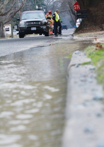
News-Argus/SETH MABRY
Water pours down the gutter of North Audubon Avenue after a Honda SUV struck a fire hydrant to avoid a collision with another vehicle early today. No injuries were reported. Roadways in and around Goldsboro were slick from the ice that formed overnight and had cars slipping and sliding, especially in curves and at intersections.
A winter weather advisory remained in effect until noon today as residents tried to cope with the aftermath of the latest wintery blast to hit the area in just weeks.
Another "big system" of what is expected to be just rain will move into the area Thursday into Friday, said Brandon Vincent, a meteorologist with the National Weather Service office in Raleigh.
While there is a chance of winter weather associated with that system, it should be to the west of the county near Raleigh and the Triad, Vincent said. Rain is expected in Wayne County on those days with a high near 45 on Thursday and 50 on Friday.
Vincent said he did not yet have any figures on ice accumulation in the county. However, it is expected to be about a tenth of an inch, he said.
Overnight winds and low temperatures resulted in a wind chill in the single digits early this morning, and the temperature will be slow to rise today, Vincent said.
It was expected to be at least noon today before the temperature struggled to above freezing before reaching an afternoon high of near 38.
There was a slight chance of rain after 11 a.m., but otherwise today should be partly sunny. There is also a slight chance of more drizzle after midnight.
The precipitation could be in the form of a light rain or possibly rain and freezing rain, Vincent said. There is another chance of drizzle before 9 a.m. Wednesday when the high temperature is expected to reach 48.
Temperatures are expected to continue to moderate through the week, climbing into the mid-60s on Saturday and Sunday.
Monday's wintery mess of ice and black ice forced schools to close and city and county government meetings to be canceled.
Wayne County schools were closed Tuesday as were Wayne Community College and Wayne Country Day School.
Goldsboro city and Wayne County offices did not open until noon today.
The regularly scheduled City Council meeting planned for last night was rescheduled for next Monday.
The work session will begin at 5 p.m. in the large conference room in the City Hall Annex with the general session beginning at 7 p.m. in the City Council chambers of Historic City Hall.
The Wayne County Board of Education rescheduled its Monday night meeting to Thursday.
Traffic crawled this morning on county roads that had been turned into ice skating rinks by Monday's mix of rain, sleet, freezing rain and sub-freezing temperatures.
People were taking cautious steps as they skated their way across ice-coated parking lots. But even then there were still several reports of people slipping and falling.
Several weather-related wrecks were reported as well.