Beach takes hit
By Steve Herring
Published in News on November 27, 2013 1:46 PM
 Full Size
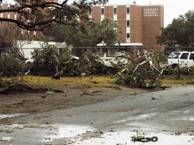
Downed trees lie scattered on the campus of Carteret County Hospital early today after a possible tornado ripped through Atlantic Beach and crossed Bogue Sound to strike Morehead City about 10 p.m. Tuesday. Damage was severe in some parts of the city and several hundred people were still without power this morning.
 Full Size
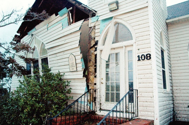
The front of this building shows the power of the winds that hit Atlantic Beach and Morehead City on Tuesday. Weather officials say they believe a waterspout might have struck the island and then the mainland.
National Weather Service crews were surveying damage in Atlantic Beach and Morehead City this morning after a possible tornado struck Carteret County on Tuesday night.
It was expected to be mid-to-late morning before a determination is made as to whether or not it was actually a tornado, said Tom Lonka, a meteorologist with the National Weather Service office in Newport.
Atlantic Beach Fire Chief Adam Snyder said the damage was the worst he's seen in his 16 years in the area.
At least three people suffered minor injuries related to the storm.
Atlantic Beach officials say two people suffered minor injuries when the roof blew off their condominium. Two of the four buildings in the complex were damaged, manager Robert Allsbrook said. As many as 15 people were in the condos when the storm hit.
Carteret Community College in Morehead City canceled classes today because of storm damage. One student was hit by flying debris, but was not seriously injured. The college's student center was damaged, as was the building used for basic law enforcement training.
"We took quite a hit," said training director Joe Rufra.
"Right now we are closing the campus to only essential workers involved in recovery and clean up," school President Kerry Youngblood said. "Safety is our main concern. There's a lot of debris and some power lines are down."
A tornado watch for several coastal counties expired at 8 a.m. this morning. However, a gale warning remains in effect until 7 p.m.
National Weather Service radar indicated a tornado and a warning was issued at 10:16 p.m. Tuesday night, Lonka said. The first calls of possible tornadic activity started at 10:20 p.m., he said.
However, a tornado cannot be confirmed until ground crews can survey the damage, he said.
"Just after 10 we got the warning," Morehead City Fire and EMS Chief Jamie Faulk said. "Within 30 to 45 seconds the power started going out and we started to get alarms. When we responded it was obvious it appeared that a tornado had touched down and done substantial damage."
Faulk said he had heard unofficial reports that a waterspout had formed off the coast and moved inland. But without an aerial view it is hard to determine how wide the storm's path was, Faulk said.
"It is a pretty good swath," he said. "This damage is pretty substantial, but not like what you see out West."
The storm took out power and did substantial damage to three buildings at the community college, along with several houses and businesses, he said.
Faulk said he expects some of the structures will have to be demolished. Building inspectors were out this morning surveying the damages, he said.
At one time, Duke Energy Progress reported about 6,000 customers without service in Carteret County. At least 500 customers were still without service this morning.
Minor damage was reported at Carteret General Hospital in Morehead City. The hospital was momentarily without power until generators were started, officials said.
Faulk said a number of vehicles and boats had been damaged as well.
Faulk said his department had not responded to any calls for injuries sustained in the storm, but did provide mutual aid to Atlantic Beach at a structure collapse.
The Red Cross has disaster personnel in the area, but no additional information on damage was available prior to press time this morning.
The storm was part of a system that swept across the state Tuesday.
"It was very quick," Lonka said. "It was a very fast moving, and strong, traveling probably greater than 40 miles per hour."
Tornadoes are unusual this time of the year but not unheard of, particularly near the coast, Lonka said.
Lingering rain is expected at the coast today with temperatures dropping as a cold front moves through.
The same storm system dumped more than an inch of rain on Wayne County, but spared it the strong winds. The rain was expected to end around 1 p.m. today with a high near 59.
Strong and gusty winds are expected later today as a cold front moves into the region, with west winds gusting as high as 33 mph. Winds are expected to diminish after sunset.
It should be mostly clear and windy tonight with a low around 27.
The forecast for Thanksgiving Day is sunny with highs near 44 with north winds from 5 to 10 mph. Thursday night should be clear with a low around 24 with calm winds.
For Black Friday, shoppers can expect sunny skies with a high near 52 and calm winds of 5 to 7 mph in the morning. Friday night should mostly clear with a low around 29.
-- The Associated Press contributed to this report.