Snow flurries, fizzles
By From staff reports
Published in News on February 10, 2011 1:46 PM
 Full Size
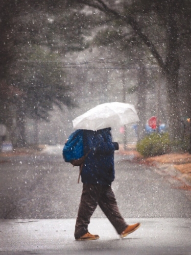
News-Argus/MICHAEL K. DAKOTA
Darrell Wallace walks down Ash Street early this morning as light snowflakes fall. Forecasters had called for possibly several inches of the white stuff, but only a slight dusting had appeared in the southern end of the county by mid-morning and skies were expected to clear later today. Friday and the weekend are expected to be sunny with highs reaching the 50s.
 Full Size
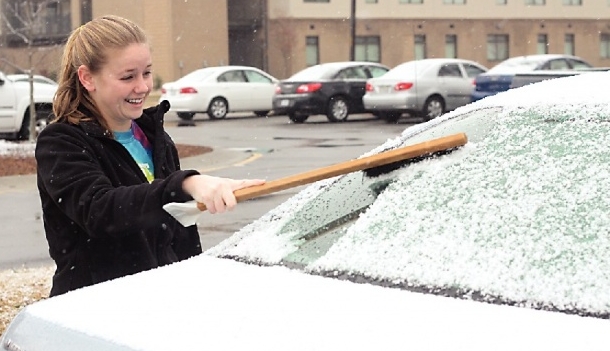
News-Argus/BOBBY WILLIAMS
Mount Olive College student Cara Paxson cleans the snow off her car's windshield this morning before heading to class. The southern part of Wayne County appeared to receive more snow than areas to the north. Forecasts were calling for the snow to end before noon and the sun to be shining later today.
A snowstorm this morning led to a two-hour delay for the start of Wayne County Public Schools as snow that had been predicted to start after midnight finally began to fall just before daybreak. Most business and government offices were open.
By 8 a.m., a steady snow was falling over most of the county with some accumulation in the southern part of the county. Wayne remained under a winter weather advisory while counties to the south and east where more snow was expected were under a winter storm warning.
A dusting to 1 inch was possible along and east of the Interstate 95 corridor. However, isolated accumulations of 1 to 2 inches could not be ruled out in the areas east of I-95.
The snow was expected to end by noon, with temperatures climbing to around 40 with a north wind between 8 and 13 mph.
No highway problems had been reported by 8:30 a.m., said Luther Thompson, state Department of Transportation maintenance supervisor for the county.
"I got to work this morning and nothing was going on and I thought it (snow) might miss us," he said.
DOT crews that spent Wednesday applying a salt brine mixture to county roads were out again this morning mainly on bridges and the major highways.
Thompson said he was on his way back to Mount Olive where it appeared to have been snowing longer and harder than in Goldsboro.
The forecast calls for mostly clear conditions tonight with a low around 22 with mostly sunny conditions and a high near 52 on Friday.
Saturday is expected to be sunny with a high near 54 climbing to near 60 on Sunday and near 64 by Monday.
Law enforcement officials in Wayne County are preparing for today's problems that may occur on the roads from the cold weather.
The state Highway Patrol canceled scheduled training sessions today to have troopers available for an anticipated increase in calls of service throughout the day.
"As the day goes on and the temperature drops, the road conditions will worsen," said state Highway Patrol Sgt. C.J. Owens.
Owens advised motorists to drastically reduce their speed if they perceive the roadways to be icy.
"Normally your bridges and overpasses tend to freeze first. And shaded areas that don't get air circulation and sunlight," Owens said.
Owens offered advice to drivers who may hit a patch of ice and lose control of their vehicle.
"The first response if you lose control is take your foot off the gas and steer in the direction of the skid," he said. He added that drivers often overcorrect by steering too sharply when they find themselves skidding.
"It's a natural reflex and people end up losing control." Owens said. "The big thing is to slow down drastically, especially if you have icy road conditions."
Wayne County was not the only place facing weather delays.
The National Weather Service issued winter storm warning for eastern counties until midday today. At least 18 school systems delayed classes by at least two hours.
Up to 4 inches of snow was expected north of a line from Greene County to northern Dare County on the coast. South of the line, forecasters expect 2 inches of snow.
Some 2 to 3 inches of snow was expected around Elizabeth City in the northeastern corner of the state.
A winter weather advisory for areas near Interstate 95 was dropped late this morning. Light snow was reported from Elizabeth City south to Cherry Point.
-- The Associated Press contributed to this report.