Snow, Part II: Slip-sliding, no school as flurries hit county
By From Staff And Wire Reports
Published in News on February 4, 2009 1:46 PM
 Full Size
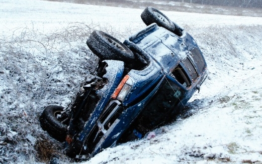
News-Argus/BOBBY WILLIAMS
A sport utility vehicle lies in the ditch off Old Mount Olive Highway early today after it slid off the icy road. Mar-Mac firefighters helped the driver out of the vehicle and she was taken to Wayne Memorial Hospital. An early morning snow and sleet storm left Wayne County roads in dicey shape and lawmen urged drivers to slow down. Roads were expected to stay dangerous as temperatures were predicted to remain near freezing until Thursday afternoon.
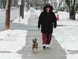
News-Argus/GREG SOUSA
Jenny Sipes walks with her dog Snookums on Walnut Street in Goldsboro on this morning. Wayne residents awoke to an inch or more of snow today, forcing schools to close.
Wayne County residents awoke to a snow and sleet storm early today, with stiff winds and slick roads that made driving treacherous and forced schools to cancel classes.
Jeff Orrock, a meteorologist with the National Weather Service in Raleigh, said this morning that Wayne County received between one to two inches of snow but that no more precipitation was expected to fall today.
Skies had cleared by mid-morning but the cold temperatures were expected to stick around. Temperatures still had not risen above the freezing mark by mid-morning and Orrock said they stay near the freezing mark again as soon as the sunshine fades.
"Temperatures will drop below freezing around 4 p.m. as cold air moves in," he said early today. It should get warmer Thursday afternoon, he added.
State Highway Patrol First Sgt. Jerry Burton said there were four troopers working Wayne County today, and all of them were on the roads.
Burton said there had been about 12 minor accidents.
"Just minor crashes, people sliding off the roadway," Burton said. "In this type of weather, people need to just slow down, to actually go below the speed limit."
Wayne County Sheriff's Office Captain Tom Effler said that with county employees operating on a two-hour delay, his staff was slowly trickling in this morning.
"I think it's worse on the south end (of the county) than it is here (in Goldsboro)," Effler said.
Wayne County Public Schools initially delayed school two hours, then after 8 a.m., concern for buses traveling on secondary roads prompted school officials to cancel classes and events scheduled for today.
It remained, however, an optional teacher workday.
Wayne Country Day School also closed, while Faith Christian Academy canceled classes and had a two-hour delay for day care and kindergarten after care.
Wayne Community College and Mount Olive College operated on a regular schedule.
Most businesses also remained open and major roadways were beginning to clear by mid-morning although many secondary roads remained icy and dozens of vehicles had slid off the road all across the county.
Orrock said the storm had appeared to be aimed for the Raleigh-Durham area as it crossed the state but hit to the east and southeast.
The emergency manager for Wilson County said he had seen about 3 1/2 inches of accumulation in some areas.
Winter storm warnings were in effect in the mountains of western North Carolina, where up to 6 inches of snow was forecast by Thursday morning. Fore-casters said 12 to 14 inches of snow was possible at the highest elevations near the Tennessee border.