Snowflakes fly across North Carolina
By Steve Herring
Published in News on January 20, 2009 1:46 PM
 Full Size
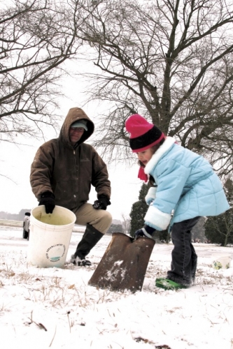
News-Argus/BOBBY WILLIAMS
Hanna Cox, 6, and her father, Stanton Cox, prepare to build a snowman this morning at their home on Steven's Mill Road. Forecasters are calling for more snow later today.
 Full Size
News-Argus/GREG SOUSA
Jim Gallagher, a transportation worker with the North Carolina Department of Transportation, leaves the Rosewood station to begin snow operations on Tuesday, Jan. 20, 2009.
 Full Size
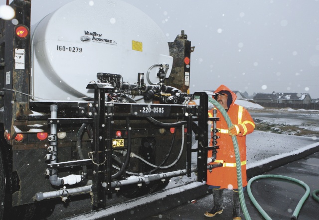
News-Argus/GREG SOUSA
Kenneth Strickland, lead worker with the North Carolina Department of Transportation, fills a truck with some salt brine at the Rosewood station on Tuesday, Jan. 20, 2009.
 Full Size
News-Argus/BOBBY WILLIAMS
The sporadic light mixture of snow, ice and rain that started falling on Wayne County around 6 a.m. today made earlier forecasts of a measurable accumulation seem less than certain. But forecasters with the National Weather Service said the county should still brace for between 2 to 5 inches of snow by mid-afternoon.
However, the real threat could be tonight and Wednesday and Thursday mornings when freezing temperatures turn the moisture into ice on bridges and roadways.
Wayne County offices, including the courts, landfill and library were closed Tuesday because of the weather. Seymour Johnson Air Force Base was on a two-hour delay.
There were no problems associated with the weather prior to 8:30 a.m., said Mel Powers of the Wayne County Office of Emergency Management.
"We are just starting to see the snow come in," Powers said. "There is about a mile visibility in the northern part of the county, but we need to remember we are getting snow and should begin to see it picking up. We are going to get two to three inches and up to possibly six to eight in some locations."
The snow isn't the biggest problem, he said.
"The biggest issue this evening and tomorrow morning is that the roadways could have black ice," he said. "You cannot see the black ice. We don't need to get complacent at what looks like a small amount of snow, there is more to it than that. Once the temperatures start dropping people need to be very cautious while driving and don't get out unless they absolutely have to."
Department of Transpor-tation county work crews weren't waiting for the snow to start.
The crews began treating the county's major highways -- U.S. 117 , U.S. 70, Interstate 795 and others, Monday afternoon with a salt brine solution. The treatment was to continue this morning, said Luther Thompson, DOT county maintenance supervisor.
From there, the crews will treat roads such as N.C. 111 and N.C. 581 and then move on to the secondary roads.
"Everything is going all right at the moment," Thompson said.
One work crew was called in just prior to midnight Tuesday since the forecast had called for the snow to start falling between then and 1 a.m.
This morning Thompson was staging his crew of about 40 workers and 27 pieces of equipment throughout the county. Adding to the state equipment were graders owned by independent contractors.
Thompson said work crews would not begin pushing the snow until about and inch and a half had accumulated and then the salt brine would be applied again.
Slush was reported on U.S. 70 and I-795 indicating that the salt brine treatment was working, Thompson said.
However, once the temperature hits 20 degrees the solution is ineffective. Thompson said he would monitor temperatures and that once they topped 20 degrees the crews would resume spraying the roads.
"We will stay as long as needed tonight," Thompson said.
Jeff Rorrock, a meteorologist with the National Weather Service Raleigh office, said that Wayne County had made the transition to freezing about 7:30 a.m. and that the snow, that had already deposited up to three inches in areas west of the county, was on the way
"We are still expecting two to three inches on the low side and possibly up to five inches before it tapers off in mid-afternoon around 2 p.m.," he said.
Dunn, Erwin and Sanford all have about three inches of snow and the system is "sliding east," he said.
"Temperatures will remain near freezing during the day," Rorrock said. "Conditions could be more dangerous Wednesday morning. Temperatures will drop into teens Tuesday night and that means anything with moisture and snow on it could freeze."
Temperatures are expected to be in the mid-30s Wednesday before falling to the low 20s Wednesday night creating the possibility of black ice.
A warming trend will start Thursday with highs in the upper 40 to low 50s.