Storms prompt tornado warning
By News-Argus Staff
Published in News on October 2, 2008 2:07 PM
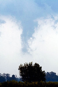
News-Argus/Bobby Williams
A storm cloud visible on Sutton Road near the Wayne/Lenoir county line.
Wayne County was pummeled by hail and heavy rain during a quick-moving storm that raced between Dudley and Goldsboro shortly after
3 p.m. Wednesday, but officials are saying that there were no funnel clouds on the ground, despite the county being under warning for slightly more than an hour.
"There were no reports of anything touching down," said Mel Powers, Wayne County Emergency Services coordinator. "There were reports of hail."
But no damage, he added.
Jonathan Blaes at the National Weather Service office in Raleigh hadn't received any reports of damage, either, but he said a crew was checking the storm's path through Wayne County.
"We received reports of hail the size of tennis balls, which is rare for around here," he said.
The storm appeared to develop in Cumberland County before moving through Sampson and Wayne counties. Its path continued through Pitt and Martin counties as well.
"We expect news later today," said Blaes. He described the storm as "a super cell that was rotating and had a good radar signature."
A potential funnel cloud was photographed by a News-Argus photographer between Seven Springs and Walnut Creek, but it did not appear to form up and touch down.