Wayne County under flood watch
By Steve Herring
Published in News on July 23, 2018 10:58 AM
 Full Size
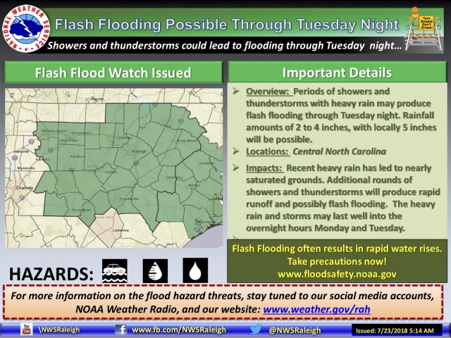
Wayne County is under threat of flash flooding over the next two days, with 2 to 4 inches of rain expected and 5 inches possible locally as a pattern of rainy weather settles over eastern North Carolina through next weekend.
The main threat is today into early Wednesday morning, prompting the National Weather Service to issue a flash flood watch for a portion of central North Carolina until 2 a.m. Wednesday.
The watch area includes Wayne, Duplin, Johnston, Lenoir, Sampson and Wilson counties.
The risk of flash flooding will be greatest during the afternoon and evening hours today and Tuesday. Some threat will persist overnight Tuesday as storms continue past midnight and into Wednesday morning.
The main areas of concern will be urban and flood-prone areas, but rural areas that see repeat thunderstorms may see flash flooding develop as well.
Flooding can also develop quickly along rivers and streams, according to the National Weather Service.
A flash flood watch means that conditions may develop that lead to flash flooding -- a very dangerous situation.
The soil over a large portion of the central part of the state has been saturated by recent thunderstorms.
According to the National Weather Service, disturbances rotating around a large upper trough will combine with a deep southerly flow and low level boundaries to produce additional rounds of thunderstorms today through Tuesday night.
People in the watch area should monitor forecasts and be prepared to take action should flash flood warnings be issued, which means that flooding is occurring.
The forecast calls for showers and thunderstorms, mainly after 2 p.m. today with a high temperature near 85. New rainfall amounts between a quarter and half of an inch are possible.
Showers and thunderstorms will continue overnight with new rainfall amounts between 1 and 2 inches possible. The low will be around 74.
Showers and thunderstorms are likely on Tuesday with new rainfall amounts between 1 and 2 inches possible. The high will be near 85.
Showers and thunderstorms are likely, mainly before 2 a.m. with new rainfall amounts between a half and three-quarters of an inch possible. The low will be around 73.
Showers and thunderstorms are likely, mainly after 10 a.m. on Wednesday with another quarter and half of an inch possible. The high temperature will be near 86.
Wednesday night showers and thunderstorms are likely, mainly before 10 p.m. producing new rainfall amounts between a quarter and half of an inch.
The chance of showers and thunderstorms continues through Sunday with temperatures ranging from the upper 80s to low 90s.