Wayne County under flash flood watch until 8 a.m. Tuesday, rain to continue through the week
By Joey Pitchford
Published in News on May 28, 2018 2:12 PM
 Full Size
Wayne County is under a flash flood watch until 8 a.m. Tuesday, with rain likely to continue throughout the week, according to the National Weather Service.
According to the NWS 7-day forecast, the county has a 90 percent chance of rain during the day Tuesday, dropping to around 60 percent by the evening. As rain continues to fall today, precipitation is expected to continue through the night, with new rainfall amounts between a half and three quarters of an inch possible.
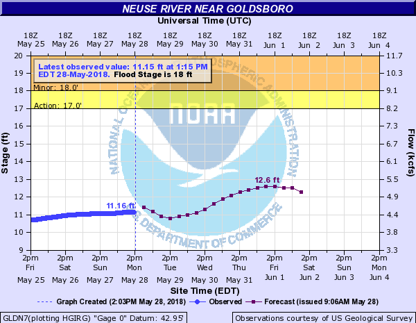
As of 1:30 p.m. today, the Neuse river sat at 11.16 feet deep, according to the NWS. The river is expected to drop to around 10.8 feet deep Tuesday afternoon, before peaking at 12.6 feet on Friday.
Mel Powers, Wayne County Office of Emergency Services director, said that OES does not expect substantial flooding anywhere in the county.
"We're going to have some localized flooding, but we don't expect it to be major," he said. "They've backed off on the numbers since yesterday."
Powers said that OES had not received any calls about flooding in county creeks or streams.
After the watch ends Tuesday morning, thunderstorms are likely during the evening, followed by showers throughout Wednesday and into Thursday, according to the NWS.
Locally, heavy rain will quickly reduce visibility and result in ponding of water on roadways, standing water in low lying areas, and minor flooding of creeks, streams, and areas of poor drainage, according to the NWS. Drivers are urged to slow down and use extra caution to avoid hydroplaning, especially in urban areas where prolonged heavy rain can quickly lead to flooding.