Neuse breaks flooding record
By Steve Herring
Published in News on October 12, 2016 9:57 AM
More photos for this story are available in the
 Full Size
News-Argus/CASEY MOZINGO
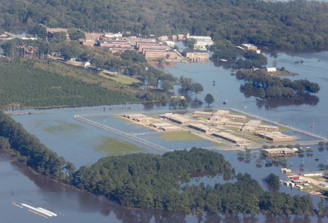
Pictured is an aerial view of floodwaters from Hurricane Matthew surrounding Neuse Correctional Institution and the old Cherry Hospital Tuesday afternoon. The Neuse River was expected to crest this afternoon, but instead crested at 5:15 a.m. at 29.74 inches. Neuse Correctional was evacuated Monday morning.
 Full Size
News-Argus/CASEY MOZINGO
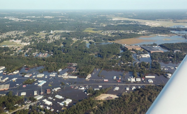
Flood water stretches out over the southwest edge of Goldsboro. U.S. 117, pictured in the bottom half of the photograph, is shut down from Interstate 795 to Old Mount Olive Highway.
The rain and wind from Hurricane Matthew are long gone -- but the Neuse River has spilled from its banks and has continued to rise since the storm blew away Sunday morning.
Water is standing or rushing across roads all over the southern and western parts of the Wayne County, leaving many residents trapped and without power and supplies.
From the air, it looks like someone cut an artery of muddy water and dumped it on top of the county.
The full extent of the damage left behind by the storm -- both financial and physical -- cannot be determined until the waters recede.
As of 5:15 a.m. this morning, the Neuse River was observed at 29.72 feet -- nearly a foot above the previous record of 28.9 feet and almost 12 feet above the 18-foot flood stage.
The river is predicted to fall to about 28.5 feet just after midnight before receding to about 26 feet by late Saturday and to 23 feet just after midnight Sunday.
Shannon Stone was driving on N.C. 111 South Tuesday morning when she came to deep, flowing water running across the highway just after Slick Rock Road.
She crossed anyway.
Twice.
"I have to go this way to get home," Stone, who lives in Dunn, said.
During her first pass through the water traveling toward Goldsboro, she filmed to passage through the water on her cell phone as a tractor-trailer passed beside her.
"That semi could've pushed me off the road," she said. "It's worse now than it was when I came through about an hour ago."
Another woman, Earnest Saunders, turned around when she reached the standing water.
She said she lives in LaGrange and works in Dudley, and was able to make it to work by 6:30 p.m. Monday, but most roadways back to her home had been blocked by flood waters when she tried to make the return trip this morning.
"I was able to get through. I had some problems, but now everything is flooded," Saunders said.
And the waters only continued to rise.
El-Roy volunteer firefighter Don Grady stopped cars at the intersection of Slick Rock Road an N.C. 111 South and urged them not to attempt driving across the road.
"I'm telling them not to go, not to cross," Grady said. "I came down here to see what it's like and NCDOT is shutting it down now."
A flyover of the county Tuesday afternoon brought into full view the extent of the flooding that is sprawling across the county.
The section of N.C. 111 South near Slick Rock Road that had begun flooding Tuesday morning was entirely covered by the afternoon.
People continued to drive through the waters around 4 p.m. Tuesday.
Much of the county suffered the same fate as N.C. 111 South.
U.S. 117, which has been entirely closed because of the flooding, is underwater near Arrington Bridge Road, with the flood waters extending nearly the entire way to SPX Transformer Solutions at 2701 U.S. 117.
Busco Beach, which is in the same area, has not fared any better. The dirt mounds that jut up out of the ground and are used for power sports are all that can be seen of the park, as the rest is underwater.
The old Cherry Hospital is standing in deep waters, as is the Neuse Correctional Facility.
Neither building is completely submerged, but from the air it looks like the buildings are resting in lake waters.
Goldsboro police officers blocked off the intersection of West Ash Street and I-795 around 2 p.m. Tuesday, and North Carolina Department of Transportation workers set up a detour to reroute people back up I-795 or into the city down West Ash Street, but blocked all access to U.S. 117.
The intersection of U.S. 117 and I-795 had flooded Tuesday afternoon, and was also closed off.
Prior to both of those intersections being closed off, officers shut down West Grantham Street on U.S. 70 due to flooding.
The southern and western ends of the city have not caught a break, either.
Many residents in those areas were evacuated earlier this week, as the water crept into the streets up from the river and turned the streets into rivers themselves.
Water has settled into patches of land either side of I-795, into land around East and West Ash Street and up behind Historic Union Station, stopping at the railroad tracks behind the old train station.
Roads continued to close throughout the afternoon as the Neuse River continued to rise, its contents hemorrhaging across the county and soaking the county at unprecedented levels.
From above, the patchwork of tall trees shooting up in between flat plots of farmland was continuously interrupted by dark, muddy, waters creeping into the city and county.
The full extent of the damage incurred by the historical flood will not be known until the waters recede.