County prepares for river's crest
By Ethan Smith
Published in News on October 11, 2016 10:03 AM

News-Argus/CASEY MOZINGO
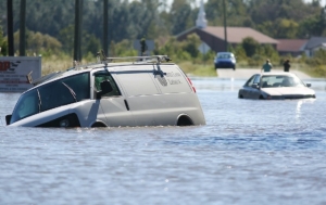
Several abandoned vehicles sit in floodwaters at the intersection of John and Benton streets Monday afternoon. The water is expected to rise through today.

News-Argus/SETH COMBS
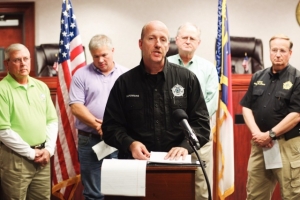
Mel Powers, director of the Office of Emergency Services for Wayne County, explains the latest facts and warnings with regard to flooding in Wayne County in the commissioners meeting room at the Wayne County Courthouse Monday afternoon. Powers gave suggestions as to how to remain safe, telling people they should boil their water as a precaution.
Officials said Monday afternoon Wayne County is experiencing historical flooding due to Hurricane Matthew, and the Neuse River is expected to crest at nearly 29 feet today at 2 p.m.
As of 6 a.m. today, the Neuse River was at 28.47 feet -- 10 feet above flood stage. The record is 28.9 feet.
The water level is expected to reach 28.8 feet at its height and remain there through midnight before receding to about 28 feet by 6 a.m. Wednesday and then to 26 feet by 6 a.m. Thursday. It is forecast to remain there trough the rest of the week.
The county and most of eastern North Carolina remains under a flood warning.
County leaders gathered at 4 p.m. Monday to deliver a news conference updating county services, road conditions and the potential added damage heaped onto a community already reeling from the Neuse River's continued rise.
Flooding has caused evacuations throughout the county and city, as well as power outages and innumerable water rescues during and after the hurricane, Wayne County Office of Emergency Services Director Mel Powers said.
"Hurricane Matthew dumped approximately 14-18 inches of rain into our county, and as an affect, we're seeing that runoff into the Neuse River," Powers said. "At this time right now, the flood stage of the river is 18 feet, currently we're at 26.51 feet. They are expecting us to crest at 28.7 feet tomorrow at 2 p.m. This is all due to storm runoff within Wayne County of Hurricane Matthew."
The Neuse River crested at 28 feet in Smithfield, and when it recedes Wayne County will see the water from Smithfield come into the county and extend the duration of the flooding. Powers said the river will drop down to 27 feet in the next few days, and will remain at that level for the rest of the week.
Powers said officials have closed the southern connector portion of N.C. 581 in the county. U.S. 70, N.C. 581, and I-795 are expected to remain open, Powers said.
U.S. 117 was closed shortly 9 p.m. Monday and a rumor began that the bridge had collapsed. It is still standing.
Roads near the river are under way in the western part of the county and that road flooding is expected in the eastern part, said Luther Thompson, DOT maintenance supervisor for the county.
As long as the roads are safe and passable the DOT will try to keep them open, he said.
Thompson said he is does not know when U.S. 117 will reopen.
The river bridge and others affected by flooding are being assessed all along to ensure that they will be safe to reopen once the floodwaters recede, he said.
Powers said many residents received a text from Duke Energy Progress saying their power would be restored by Sunday, Oct. 16.
"Just so you know, that is something they send out to everybody, so everybody got that text that they would get their power put back on October 16," Powers said. "They are working very diligently to get our power back up. The only obstacle they're having now are flooded areas they cannot get technicians into some of these flooded areas, but they are working hard."
Sheriff Larry Pierce announced a curfew -- in effect from 9 p.m. to 6 a.m. until further notice -- for both the city and county. No alcohol will be sold during curfew hours, he added.
Pierce said there have been two deaths during the hurricane, neither of which was related to the storm.
One death occurred in a shelter, and another happened when someone called authorities to report they had found somebody unresponsive in a car.
Both people died from cardiac events, Pierce said, and not from circumstances related to the storm.
Many residents throughout the city had to be saved from rising waters Monday.
Residents around McDaniels Avenue and West Robson Circle were rescued from floodwaters by the Goldsboro Fire Department by boat Monday morning.
Less than half a dozen people had to be pulled out of the area, but the Goldsboro Fire Department's training area was flooded by the rising water.
At around 10 a.m., a woman drove her GMC Yukon into standing water at the Bojangles at 811 W. Grantham St. and became trapped.
Goldsboro Police Department traffic officer Jay Holland and National Guard First Sgt. Chris Jones rescued Melinda Valasek, and her two daughters, Isabella and Lilly, from the vehicle.
Holland pulled out Melinda, while Jones pulled out Isabella and Lilly.
"We were called in from Williamson and I told my guys I would buy them breakfast, so we stopped here at Bojangles," Jones said. "We were just at the right place at the right time."
Powers and other officials are urging people to not drive through standing water, calling it a threat to life and safety.
"If you are out driving and you come across a road that is flooded out, we ask that you do not try and drive through it," Powers said. "Five inches of moving water can pick a car up and float it off."
Residents of South Alabama Avenue and other areas surrounding H.V. Brown Park were also inundated with water Monday, and residents began voluntarily evacuating the neighborhoods early in the afternoon.
Bernice Reid, who lives at 315 S. Alabama Ave., said the water began coming up her road around 7 a.m.
"Basically everybody is gone already." Reid said. "A few left in Sherard Court but there are some people still over there."
Tina Brown lives in the area and said she planned to stay until the flood waters receded.
She said her street, which intersects South Alabama Avenue, flooded during the hurricane, then the waters receded before coming back and flooding the neighborhood Monday.
"The fire department came and told us to leave, so we went to a shelter," Brown said. "We came back this morning from the shelter and now it's flooded."
Goldsboro Police Chief Mike West said the Goldsboro Police Department has been busy evacuating citizens in low-lying areas and transporting diesel fuel to the city's water pump station so the water pumps do not cut off.
West said there has been a slight increase in calls of breaking and entering happening during the night at various residences.
"What is happening is people are calling us the morning after they had to leave their home and notifying us that their homes were broken into," West said.
But there has not been an uptick in violent crime during the floods, West said.
"We've had a few shots fired calls, but have been unable to find any evidence any shots were actually fired," West said.
Many traffic lights are out throughout the city, and police officers have not been directing traffic at traffic signals that are out.
"We don't have the resources to man every intersection to direct traffic," West said. "People should treat intersections where stop lights are out as a four-way stop."
West added the police department has not seen a spike in traffic accidents, and has placed generators at major intersections along Ash Street to keep traffic signals working.
"Heed the warnings, stay at home," West said.
-- Staff writer Steve Herring contributed to this report.
