Hog, poultry farm maps available
By Rochelle Moore
Published in News on July 6, 2016 1:46 PM
 Full Size
Submitted photo
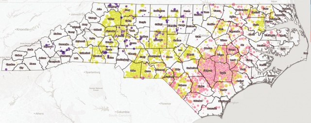
The Waterkeeper Alliance and Environmental Working Group have mapped the locations of hog, poultry and cattle operations across North Carolina. Hog farming operations are centered in Sampson, Duplin, Greene and Wayne counties.
Interactive online maps showing the locations of 6,500 hog and poultry farming locations across North Carolina are now available to the public.
The maps, which took three years to create, were recently released by North Carolina riverkeepers, the Waterkeeper Alliance and Environmental Working Group, based in Washington, D.C.
Maps that show an overview of North Carolina, county-by-county data and the impact on watersheds are available at www.ewg.org/research/exposing-fields-filth.
The documented locations are the first-ever available that show the locations of 3,900 poultry farms and the combined locations of hog, cattle and poultry operations across the state.
"For far too long, North Carolinians have been kept in the dark about the true impact these industrial factory farms are having on communities and waterways," said Marc Yaggi, executive director of the Waterkeeper Alliance.
"Information is power and now that these sites are definitively identified, we will hold accountable the N.C. Department of Environmental Quality and the U.S. Environmental Protection Agency for enforcing the Clean Water Act and fixing these massive pollution problems."
Included in the mapping are aerial views of the farming operations, including more than 4,100 hog lagoons statewide. Nearly 50 percent of all hog lagoons in North Carolina are concentrated in Duplin and Sampson counties, just south of Wayne County. Wayne County has its highest concentration of lagoons in the south and the east.
The proximity of hog lagoons to streams, rivers and public water resources area also documented statewide.
Concern exists regarding the overall impact of the farming operations on public health and the environment, including the Neuse River basin, said Matthew Starr, the Upper Neuse riverkeeper.
"It's not just the Neuse River," Starr said. "It's about the smaller tributaries that flow into the Neuse River. We know, without question, through our own sampling and peer-reviewed surface studies and (U.S. Geological Survey) studies that these industrial facilities have very negative impacts on water quality."
The Neuse River basin is a 6,000-square-mile area from Person County to the Pamlico Sound that includes freshwater streams, reservoirs and lakes and saltwater streams. The basin, which encompasses all or portions of 18 counties, is located throughout most of Wayne County.
The interactive maps have been released to provide a resource to the public and to arm environmental watchdog groups interested in increased state regulation, Starr said.
"The reason behind all this is to show the sheer number of the swine and poultry production facilities and the impact they have on these water resources," Starr said. "It's important for the general public to know about these facilities and the impact they have on these water resources."
Riverkeepers believe tighter regulations need to exist for the poultry industry. Starr said industry leaders also need to take responsibility for the treatment of lagoon waste.
"I think the companies should pay to have this waste treated so we can protect our farming heritage and clean water," Starr said. "The way the swine industry and poultry industry are regulated is uneven. We'd like to see different industries held to the same standards.
"The poultry industry has a long way to go. There's little regulation on poultry waste. That is absolutely something we would like to see changed."
In addition to the maps, the Waterkeeper Alliance and Environmental Working Group documented some of the widespread impacts the industries are having on the state.
Key findings show that each year, 10 billion gallons of wet animal waste and more than two million tons of dry poultry animal waste is produced in North Carolina.
Lagoons contain hog waste in an amount equivalent to the amount of water that could be stored in 15,000 Olympic-sized swimming pools.
The state's 4,145 documented hog lagoons represent 288 that are within a half-mile mile of a church, 170 that are within the state's 100-year floodplain, 136 that are within a half-mile of a public water well, and 37 that are within a half-mile of a school.
Statewide, the number of poultry housed at concentrated animal farms outnumber residents by 20 to one, the report shows.
"Animal agriculture operations are one of the leading sources of water and air pollution in the country and are making people sick," said Ken Cook, president and co-founder of the national Environmental Working Group. "These maps show for the first time, that thousands of CAFOs and the animal waste they produce are often adjacent to communities and vital water sources."
Starr said efforts are underway to educate state and local officials about the cumulative impacts of the hog and poultry industries in North Carolina.
Since the release of the maps, organizations involved in the study are being criticized as anti-farming.
"I am a native of North Carolina," Starr said. "I served in the Army and deployed to Iraq. To say I'm anti-farmer is inaccurate. I support farming and water quality."