More snow predicted for today; clearing for weekend
By Steve Herring and Matthew Whittle
Published in News on February 13, 2014 1:46 PM
 Full Size
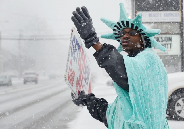
News-Argus/CASEY MOZINGO
Liberty Tax mascot Michael Taylor waves to commuters in front of the business on Ash Street. Taylor said he had to dance around to stay warm and wear sunglasses to keep the snow out of his eyes.
 Full Size
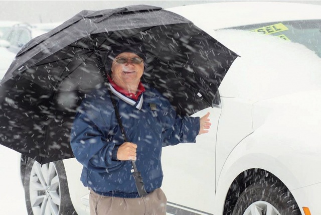
News-Argus/SETH MABRY
Shell Davis, a salesman at Frema Motors, uses an umbrella to ward off the ice and snow at the car dealership on Wednesday.
 Full Size
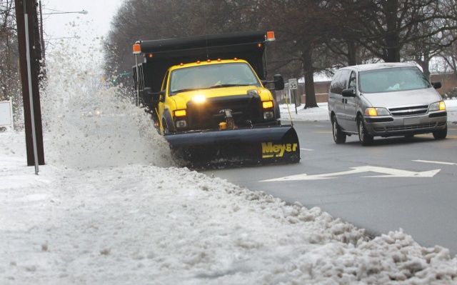
Jim Crouch
A Goldsboro snowplow cleans the remnants of ice and snow left from the winter storm on Ash Street.
Despite forecasts showing the mixed bag of snow, sleet, freezing rain and rain coming back again today, many Wayne County residents woke up this morning to find the roads surprisingly clear.
As the snow moved in Wednesday about 11 a.m., quickly covering roads and making for slippery conditions, many area businesses closed early. Wayne County and Goldsboro government offices, the public schools and all Wayne Community College sites remain closed today.
However, Wayne County came out better than its neighbors to the west where traffic snarled for hours, people abandoned their cars along roadways and homes lost power. In Wayne County, wrecks and traffic problems stayed at a minimum, and both Duke Energy and Tri-County Electric were reporting no outages this morning.
The storm dropped between two to three inches of snow across parts of Wayne County, tapering off to lesser amounts toward Mount Olive and Seven Springs before turning to a mix of sleet, freezing rain and rain Wednesday afternoon.
The winter storm warning remains in effect until 6 p.m. today as light rain and drizzle were expected across the Goldsboro area this morning, followed by a mixture of snow and rain between noon and 4 p.m., and then snow likely between 4 and 8 p.m. Forecasters estimate about an inch of accumulation is possible, with heavier amounts to the north and west toward Wilson and Smithfield.
On Wednesday, a heavy blowing snow hit just before 11 a.m. and within less than half an hour had covered the roads.
The sleet started around 1 p.m. followed by freezing rain.
But it could have been worse had it not been for the warmer temperatures pushed inland by a coastal low, said Scott Sharpe, a meteorologist with the National Weather Service office in Raleigh.
"It looks like you got very little ice if any," he said. "It looks like the warmer temperatures came in about 9 or 10 o'clock last night and you guys were in the mid-30s for a good bulk of the night. So any ice accrual occurred further to your west -- more toward western Johnston County and Wake County.
"You really dodged a bullet a little bit just because there was a pretty good area of rainfall that went across the area through the evening. But with temperatures around 34 degrees, it really didn't amount to much."
In Raleigh, the ice was just under a quarter of an inch, he said.
The temperature was expected to drop back down to freezing this morning, but Sharpe said he does not expect icing to be factor because of the nature of the system.
"The air is just too cold aloft," he said. "So it will mainly fall in the form of snow. There may be some mixture with rain possible. Temperatures will be above freezing so there shouldn't be an ice accrual going on with this.
"Now, once the skies do clear off tonight though, any moisture left on the roadways will refreeze. Plunging temperatures by tomorrow morning will be around 27 degrees. So the roads could be a little treacherous by tomorrow morning."
State Department of Transportation crews are working hard to keep the roads clear, said Luther Thompson, DOT maintenance supervisor for Wayne County.
"We worked around the clock last night," he said. "We finished pushing all of our four-lane roads last night and all of our primary two-lane roads got cleared last night. There might be one we will have to go back and do some touch up work on.
"Most of the primary roads were cleared this morning. This morning we are going to break off into our sections that we have the county broke into and start on our secondary roads."
When the snow started, he said, many of his trucks were in the southern part of the county and got hung up in traffic as people went to lunch and employers sent workers home.
But within an hour the traffic had died down as the crews concentrated on the four-lane roads in the county, Thompson said.
It was much the same story in the city, where Goldsboro Public Works Director Jose Martinez said his crews worked until about 8:30 p.m. Wednesday, stopping once the slush began to harden.
He said that they were actually at lunch when the snow began to fall and within 20 minutes, the roads had gone from black to white.
"I said, 'Time to get up and get going,'" he said, adding that they worked with DOT, as well as the police and fire departments to hit the slickest spots first before moving on to the rest of the roads.
The cold temperatures from Tuesday, he explained, allowed Wednesday's precipitation to quickly cover the roads, but because they had also laid salt and sand down Tuesday, the moisture created its own brine, which helped to prevent later freezing.
By the time his crews knocked off for the night, Martinez said, they had cleared almost every road, save two subdivisions in the northeast part of the city where the plow working there actually broke. Those roads were cleaned up this morning.
The higher temperatures overnight, combined with several hours of just plain rain, also helped to clean off most of the roads this morning.
Thompson agreed that the warm temperatures made a difference.
"It really didn't freeze anything on the pavement. It just left it slush," he said. "It was really just kicking the slush off last night and hitting some icy spots that were real thick from yesterday. I think the rain helped out a lot last night."
Thompson was out early this morning checking "back roads."
It appears just to be "pure slush" on the roads and Thompson is hopeful crews will be able to clear before the next round of snow and falling temperatures.
However, motorists still need to exercise caution, particularly in the morning because of possible icing, especially on overpasses and in shaded areas.
"Even if you think the road looks good, please be careful," Martinez said. "You never know when you might hit a shaded spot that's still slick."
Thompson agreed, cautioning people to continue to reduce their speed and give themselves more time.
"Hopefully by this afternoon road conditions will be better," he said.
Most of the work today for both NCDOT and city crews will be pushing the slush off the roads and treating any remaining spots. They also will have salt, sand and brine ready in case they find patches of ice.
As for today's forecasted precipitation, Martinez said he does not anticipate it creating any more problems.
"As far as storms go, this worked out pretty nice," he said. "And it shouldn't snow enough today for us to break the plows back out."
But both city and state crews will be on standby just in case.
Looking toward the weekend, temperatures are expected to moderate, but a chance of snow flurries will continue into Sunday morning.
Friday's high is expected to be near 49 with a chance of rain Friday night.
Saturday is forecast to be sunny with a high of near 45 falling to around 29 Saturday night. There is a chance of flurries after 11 p.m.
There is a chance of flurries as well before 10 a.m. Sunday before becoming mostly sunny with a high near 51.