Crashes with deer rank high in region
By Steve Herring
Published in News on October 10, 2011 1:46 PM
 Full Size
NC DOT
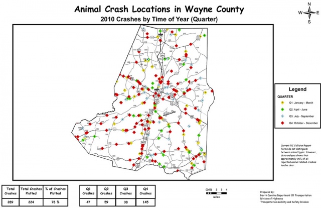
Reported collisions between animals and vehicles in Wayne County from the North Carolina Department of Transportation.
It is that time of year again -- when deer become a much more common sight on county roads -- and their encounters with vehicles on local roadways increase as well.
Wayne and five surrounding counties rank among the top 25 in the state when it comes to wildlife-related automobile crashes, according to state Department of Transportation statistics.
There were 852 such crashes in Wayne County between 2008 and 2010, placing the county 25th on the list. During 2010, there were 289 crashes putting the county at No. 30.
During 2010, there were 47 crashes between January and March in Wayne County; 59 between April and June; 38 between July and September; and 145 between October and December.
Most of the animal-related crashes happened south of U.S. 70, although there were clusters of crashes just east and north of Goldsboro. Many of the crashes occurred along U.S. 117 south from U.S. 70 to just north of Mount Olive and along U.S. 13 South. There also was a concentration of crashes on U.S. 70 west of Goldsboro.
Between 2008 and 2010, there were 60,045 animal-related collisions reported throughout the state. Since 2008, the incidents statewide have resulted in injuries to 3,453 people, including 17 fatalities, and nearly $136 million in property damage.
Current state collision report forms do not distinguish between animal types. However, of the more than 19,500 animal-related crashes reported each of the last three years, 90 percent involved deer.
The top five counties for such collisions in 2010 were Wake (1,051), Pitt (713), Duplin (646), Guilford (635) and Randolph (534). Wake County has had the most animal-related crashes for the past 10 years.
In Duplin County 1,792 crashes were reported for 2008-10 to rank third while Pitt had 1,777 (fourth place) and Johnston, 1,465 (sixth). Sampson County had 964 crashes (19th place); Lenoir, 905 (22nd); Wilson, 710 (39th); and Greene, 384 (57th).
Duplin County recorded most of its 2010 crashes, 299, between October and December. There were 139 between January and March; 107 between April and June; and 101 between July and September.
DOT officials remind motorists to be aware of the increased presence of deer on state roads during this time of the year.
Crashes are most common during the hours of 5 p.m. to 7 a.m., when deer movement increases and limited lighting makes it more difficult for motorists to see them on or near roadways.
DOT offers the following suggestions for motorists to avoid being in collision with a deer:
* Slow down in posted deer crossing areas and heavily wooded areas, especially during the late afternoon and evening.
* Statistics indicate most car-deer crashes occur near bridges or overpasses. Deer also follow railroad tracks, streams and ditches.
* Drive with high beams on, when possible, and watch out for eyes reflecting in the headlights.
* Remember that deer often travel in groups, so do not assume that the road is clear if one deer has already passed.
* Do not swerve to avoid contact with deer. This could cause the vehicle to flip or veer into oncoming traffic, causing a more serious crash. Swerving also can confuse the deer as to where to run.
* If you see a deer near or on the road, give your car horn one long blast. This sound gives the deer an audible signal to avoid.
* Increase the distance between your vehicle and other cars, especially at night. If the car ahead of you hits a deer, you may also become involved in the accident.
The North Carolina Animal-Related Crashes 2008-2010 data and county rankings can be found at www.ncdot.org/doh/preconstruct/traffic/Safety/crashdata/data/animal.pdf. DOT also has animal crash maps available by county at www.ncdot.org/doh/preconstruct/traffic/Safety/crashmaps/Animal_Maps.html.
A county spreadsheet will load with links to the maps. The crashes are coded by the quarter of the year they occurred.