River expected to crest at 22.1 feet, some streets flood
By Steve Herring
Published in News on April 25, 2017 9:49 AM
 Full Size
News-Argus/STEVE HERRING
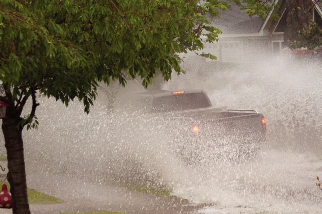
A pickup truck is nearly obscured by plumes of water as it drives through a flooded section of East College Street in Mount Olive Monday evening. There were reports of flooded streets in Goldsboro and northern Wayne County as well.
 Full Size
News-Argus/STEVE HERRING
Heavy rainfall over the past 24 dumped anywhere from 2 inches of rain in southern Wayne County to 5.5 inches in northern Wayne County leaving some streets, such as this one in Mount Olive temporarily flooded. The rains are also swelling the Neuse River that is forecast to reach its 18-foot flood stage just after midnight.
The Neuse River is forecast to reach its flood stage of 18 feet shortly after midnight before cresting at 22.1 feet around 6 a.m. Sunday, according to data released this morning by the National Weather Service. That level is considered to create moderate flooding.
The record level of 29.7 feet was set last October in the aftermath of Hurricane Matthew.
A flood watch for Wayne County and most of central North Carolina expired at 8 a.m. Tuesday, but a flood warning remained in effect until 11:15 a.m.
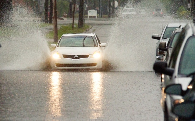
And the heavy rains over the past 24 hours flooded some streets in Goldsboro and Mount Olive and helped swell the Neuse River.
On average, the county received 4 inches of rain with a slightly lower total in the southern part of the county.
Northern Wayne County, where most of the road flooding was reported, received 5 inches.
Water covered sections of Big Daddy's Road, Buck Swamp Road, Norwayne School Road and Morris Road.
However, since the rain subsided some this morning, those areas should drain pretty quickly, said Mel Powers, director of the Wayne County Office of Emergency Services.
Powers said he had received no reports of traffic accidents related to the storm. Showers are likely through the morning and then showers with possible thunderstorms also possible after 3 p.m. There is also a chance of showers and thunderstorms before 8 p.m. and then a slight chance of showers between 8 p.m. and midnight.
Skies are forecast to be mostly sunny or partly cloudy through the weekend with temperatures in the upper 80s to low 90s.
State Department of Transportation officials warn motorists not to drive through pools of standing water, even if a pool appears shallow since it could be covering road hazards such as holes, fallen power lines or debris.
Over half of all flood-related drownings occur when a vehicle is driven into hazardous floodwater, and less than two feet of water can carry away most vehicles.
If line markings on the road are not visible, do not drive through the water.
If your vehicle starts to hydroplane, take your foot off the gas and apply the brakes in a steady, slightly firm manner and steer in the direction of the skid.
No major problem areas were found in Goldsboro this morning, but crews are monitoring the level of Stoney Creek, especially near Elm Street where the water continues to rise, said Rick Fletcher, Goldsboro public works director.
No road closings have taken place in the city, but areas along the creek will be monitored today. Crews are also watching city storm drains for street flooding.
"Stoney Creek is flooded, but it's not shut any roads," Fletcher said. "Right now, there's no major concerns. We're just monitoring Stoney Creek. We've come out unscathed so far."
As of 7 a.m. Tuesday, the Neuse River had reached 11.08 feet -- climbing from just under five feet on Monday.
At 18 feet, water begins to overflows the riverbanks and at 19.5 feet, Ferry Bride Road near Grantham begins to flood, according to the Federal Emergency Management Agency.
Arrington Bridge Road and access roads around Seymour Johnson Air Force Base flood at 20 feet and at 21 feet, Riverview Trailer Park homes and Stevens Mill Road begin to flood, according to the FEMA data.
-- Staff writer Rochelle Moore contributed to
this report.