High winds cause many power outages, much storm damage
By Matthew Whittle
Published in News on August 28, 2011 1:50 AM
 Full Size
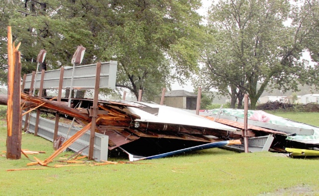
News-Argus/BOBBY WILLIAMS
A large billboard located on U.S. 70 East near Wilber's Barbecue shows the power of Hurricane Irene as she passed along the coast.
 Full Size
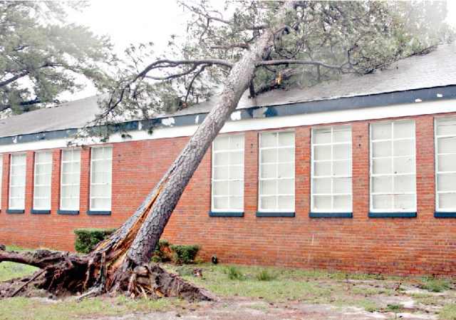
News-Argus/BOBBY WILLIAMS
A large pine tree in front of Eastern Wayne Middle School was blown onto the roof of the school by the strong winds from Hurricane Irene. School officials will be out early Monday checking the schools across the county.
County officials expressed relief Saturday as they began to close down their emergency shelters that Hurricane Irene, though long-lasting, had not been any worse than it was.
"We feel as though we were very fortunate, especially if you look at the coastal counties and the counties east of us," said Wayne County emergency management and security director Mel Powers. "I'm kind of pleased with how everything went. I think we did real good."
He said that all told, the county's two shelters served about 130 people Friday night and Saturday, and that by 9 p.m., they had closed the overflow space at the Wayne Academy on Lionel Street and were considering closing the Salvation Army shelter on North William Street where only one person remained.
Across the county, he said, there were spots of damage -- houses with trees on them, the collapsed roof of Goldsboro's Berkeley Mall, a tree leaning on Eastern Wayne Middle School, tobacco barns with tin ripped off -- but that most of it was relatively minor, and that none of it involved any sort of notable flooding.
As of 10 p.m. Saturday, though, nearly 24,000 Progress Energy customers -- down from a height of nearly 27,000 earlier in the day -- and more than 10,300 Tri-County Electric customers were without power, with few restoration estimates available as crews were still assessing the widespread damage.
And because of all those widespread downed trees, power lines and power outages, emergency officials declared a countywide curfew, including all the municipalities, from 9 p.m. Saturday to 5 a.m. today
"It's just to keep people off the road," Powers said. "People not familiar with where they are, out driving around, could hit a power line, a tree. We've already had one fatality. We felt the curfew would just help eliminate all that."
Officials do not, however, expect it to continue tonight, though.
"We'll assess it (today), but I think it's going to be a one night event," Goldsboro City Manager Scott Stevens said.
Now, officials said, the next step will be to get out today and begin clearing debris off streets and assessing damage.
"We had a lot of trees falling down, but I think otherwise we fared well. The first goal will be getting streets open," Stevens said.
Once that's done, he said, they will begin clearing the debris from the right-of-ways.
"We'll need people to be patient with that part. That could take some time," he said.
On the county side, Powers said, officials will be taking to the roads to begin doing "dashboard assessments" -- quick surveys to see where and roughly how much damage occurred throughout the county.
"It's nothing definitive for the insurance companies. It's just for the county's knowledge so we know what happened where," he said.
All in all, though, he reiterated that he felt the county was fortunate, especially given how the track of the storm changed so much in the days leading up to Saturday.
"The first part of the week we thought we were going to be hit hard, and then it wobbled to the east, putting us out of it and we kind of relaxed, and then the next day (Friday) it was back to the west, so yes, I think we fared well," he said.
And, he added, the county's emergency systems worked as they were supposed to -- even the radio system.
"It seemed as though the radio system worked better than it ever has. I don't think I heard a single complaint. I think it did exactly what we hoped it would do," he said.
And late Saturday, as Irene moved out of the area completely, Bradley McLamb, meteorologist with the National Weather Service, said Wayne County appeared to have received between 5.5 and 6.5 inches of rain, more toward the east, and to have had sustained winds of 40 to 50 miles per hour at the top end, and gusts up to 62 miles per hour. But the most significant part of the storm, he said, was the fact its impacts lasted from mid-afternoon Friday until midnight Saturday.
"It was definitely a large hurricane -- not anything exceptionally unusual, but definitely a large storm," he said.
Today, though, added, is expected to be "a nice, sunny and warm day."